Country Profile
 Location
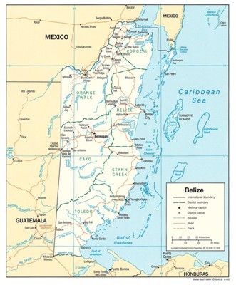
Belize previously known as British Honduras, lies in the East coast of Central America in the heart of the Caribbean Basin, bordering on Mexico to the North, Guatemala to the West and South, and flanked by the Caribbean Sea to the East.
Geography
The barrier reef, the cayes (pronounced keys), and the offshore atolls, are the main attractions in Belize. The 185 mile-long barrier reef is the longest reef in the Western Hemisphere. The cayes are islands or mangroves which are located on or around the barrier reef. Although the mangrove cayes are normally uninhabitable by humans, they do provide a superior habitat for birds and marine life,many of which begin their lives within the protection of mangroves. On the other hand, the island cayes, which are distinguishable by their palm trees, have provided the foundation for the development of many fine resorts to serve water sport enthusiasts and marine naturalists. The cayes and atolls provide superior opportunity for SCUBA, snorkeling, fishing, boating, sailing, sail boarding, and sea kayaking, as well as habitat for both nesting birds and turtles.
The northern half of the Belizean mainland is a plain that was once a sea bed. The land is covered with a thin layer of soil that supports scrub vegetation and dense hardwood tropical forest. The coastal area is neither land nor sea, but instead is a sodden, swampy transition between the two. The coast consists of mangrove and grasses, and it is bordered by tussock grasses, cypress and sycamore trees where the land separates the water.
The central part of Belize consists of sandy soil that supports large savannas. Approximately thirty miles southwest of Belize City, in the enchanting Mountain Pine Ridge District and the Maya Mountains, the land begins to rise dramatically from anywhere between 1,500 and 3,680 feet above sea level. Abundant rainfall runs off the northwest from the highlands in a number of streams which flow into the Macal River. Ultimately, the Macal River and the Mopan River converge to provide the headwaters of the Belize River.
The southern part of Belize, with its watershed down the Maya Mountains and to the southeast, consists of short rivers that rush through slopes combed with overhanging ledges and caves. The Rivers which carry sand, clay and silt have enriched the coastal belt over the years and allowed Belize to develop significant agricultural products such as citrus and bananas. Along with an annual rainfall of some 170 inches, southern Belize has a true tropical rain forest that is rich with ferns, palms, lianas, and tropical hardwoods.
 History
The first inhabitants of Belize were the Maya. Belize was a part of the great Mayan empire which stretched through Guatemala, Southern Mexico and parts of Honduras and El Salvador . Though their history can be traced back over 4,000 years, the Classic Period of more advanced Mayan civilization began around the 3rd century AD and reached its height between the 6th and 8th centuries. By the 14th century Mayan civilization was in serious decline, and when the Spanish arrived in the 16th century many of the Mayan cities were deserted.
The Spanish considered Belize suitable only for cutting logwood to be used for dye, and although the Spanish 'owned' Belize they did not rule it. The lack of effective government and the safety afforded by the reef attracted English and Scottish pirates during the 17th century. When piracy became outdated, many of the pirates began worlung in the logging trade. The British settlers brought their culture and customs to Belize, and the country was released from Spanish rule when the Spanish Armada was defeated in 1798. Then in 1862, while the USA was embroiled in its Civil War and unable to enforce the terms of the Monroe Doctrine, Great Britain declared Belize to be the colony of British Honduras.
After WWII, the Belize economy weakened, leading to agitation for independence. Democratic political parties and institutions were formed and self-government was granted in 1964. The government decided to build a new capital at Belmopan in 1970, after Hurricane Hattie all but destroyed Belize City in 1961. Full independence became a reality in 1981 when British Honduras officially became Belize. Guatemala, which had territorial claims on Belize, threatened war in 1972, but British troops were stationed in Belize to make sure the dispute remained purely diplomatic. During the volatile 1980s, Belize remained stable, thanks predominantly to large influxes of US aid. In 1992, a new Guatemalan government recognized Belize 's territorial integrity, and the British garrison was withdrawn in 1994.
Climate and Rainfall
Belize's climate is subtropical with a brisk prevailing wind from the Caribbean Sea. The country has an annual mean temperature of 79 degrees Fahrenheit, and the humidity is nicely tempered by the sea breezes. Variation in weather features emphasizes the interesting difference in elevation, geology, plant and animal life.
Summer temperatures usually never exceed 96 degrees Fahrenheit, and winter lows are seldom below 60 degrees Fahrenheit even at night. Saltwater temperature ranges from 75 to 80 degrees Fahrenheit.